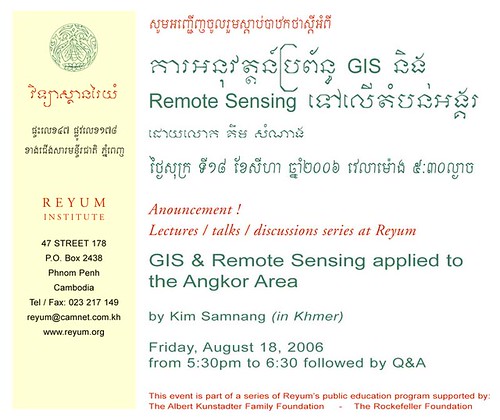
Tech Talk If you're a techie and this is your kinda thing, check it out. The world is being mapped out, and here's a rare explanation in Khmer. As with history, geography can be pretty contentious. Who does the mapping? What for? Who has access? Who gets to choose labels? Considering how people get worked up about Cambodia's border, this talk actually might be pretty relevant to the larger context. Announcement! Lectures/Talks/discussions series at Reyum GIS & Remote Sensing applied the Angkor Area by Kim Samnang (in Khmer) Friday August 18 2006 5:30pm to 6:30 followed by Q&A This event is part of a series of Reyum's public education programs The Albert Kunstadter Foundation / The Rockefeller Foundation Reyum Institute 47 Street 178 P.O. Box 2438 Phnom Penh Cambodia Tel / Fax: 023 217 149 reyum@camnet.com.kh www.reyum.org [from What's On]
- jinja Link
HOME
about
archive
travels
contact
linkage
Anonymous comments are deleted. Emails related to this blog may be reprinted.
Popular Posts:
Gunplay
Miss-Khmer-ica
Couches and Controversy
Street Kids Shoot Back
Phnomenon Interview
Links:
Arts
What's On - Cambodia Arts News
Sovanna Phum
Java Arts
le Popil
Cambodian Comics
Sporadic Cartoon
Komik Cambodia Exchange
Rajana Society
Reyum
Arijan Jansonius
Lakhorn Kou
Virtual Lotus
Saklapel.org
Nou Hach Literary Journal
Art House, Siem Reap
Nonprofits
Libellus Association
Osmose
Cyclo Centre
Gecko Centre
Heritage Watch
Khmer Operating System
Santapheap
'Our Village'
Profits
KhmerProducts.com
Digital divide Data
Hagar Soya
Schooling
EFEO
Center For Khmer Studies
Bophana Center
SE Asia Archaeology Blog
Youth Infotech Workshops
Center for Advanced Study
Online Khmer Dictionary
Other Cambodia Blogs
Analog Cambodia
Andy Brouwer
Chath
Tharum
Phnomenon
Khmerang.com
Cambochica
Wanna
Cambodia4Kids
That'll Do
Mongkol
Mungkol
Details Are Sketchy
Stefan's Blog
Virak
Jeff's Jungle
Vuthasurf!
Steve Goodman
traactivity
Khmerbird
Earth's Molten Core
Kampuchea Crossings
Vanndeth
Squatter
Parish without Borders
PreahChan
Pepy Ride
Down the Road: Cambodia
Danny's Weblog
Phnom Penh Tagebuch
Reporter at Large
Kalyan Keo
Illuminating Cambodia
'Embassy' Blog
Srei Saat
transit
Khmer Cyberkid
Mistaken for Khmer
Cam-Blog
Cameras 4 Cambodia
Listings
Expat-Advisory.com
'Planet Cambodia' blogs
Technorati's 'Cambodia' blogs
Global Voices
Global Voices Wiki Archived
Blogger's 'Cambodia' list
Topix.net: Cambodia blogs
travel
Hidden Cambodia
Tales of Asia
Canby Publications
AsiaLifeCambodia
Gratuitous Linkage
Manur.org
travel-itch
Sweet Cucumber
anth
jemisa
van-vanity.de
Maytel 2020
Camelfish
Spikor
lorraine crescent
Geminianeyes
Kamigaroshi
Eternal Wanderer
EducateDeviate
Somesaypip
Rambling Spoon
Jemisa's Back!
dev.null.org
KiwiBopha
Gombe Chimpanzee
RSS feed
« Asia Expats Ring » ?
Blogdup